Data Centers from the SkyBy Sune Christesen, Oct 15 2009
Seen from above large data centers are often easy to recognize, due to the large amount of cooling equipment, antennas etc. that usually are located either on the roofs of the data centers or around the buildings.
With the availability of satellite images and images shot from planes via Google Earth and Live Maps, it is possible for us to get a sneak peak of some of the more interesting data centers seen from above:
Connectivity
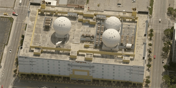
NAP of the Americas, Miami
Below is an overview of Terremarks NAP of the Americas facility in Miami, showing their three up to 16 meter huge sattelite antennas. The satellite dishes are intended as backup in case of a total loss of fiber connectivity, even though it is an unlikely scenario. More details about the satellite installation can be found at Data Center Knowledge.
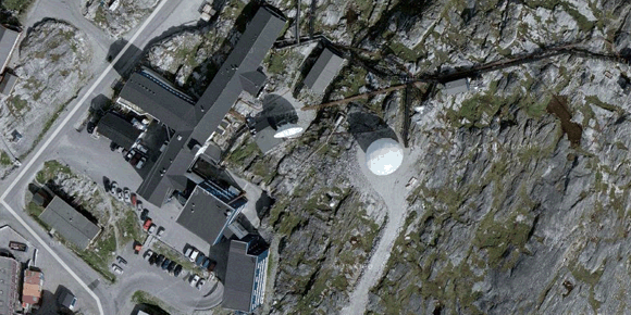
Tele Greenland, Nuuk
This satellite photo shows two large satellite antennas at Tele Greenlands data center in Nuuk, which due to their very remote location has been Greenlands primary connection to the outside world. Recently a submarine cable was finished, Greenland Connect, connecting Greenland to Canada and Iceland.
Cooling Equipment
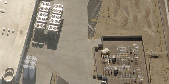
i/o Data Centers, Phoenix
Below is a shot viewing part of i/o Data Centers recent data center, Phoenix ONE, with an example of just how big cooling equipment can be at large data centers. Notice the size compared to the car in the lower right corner.
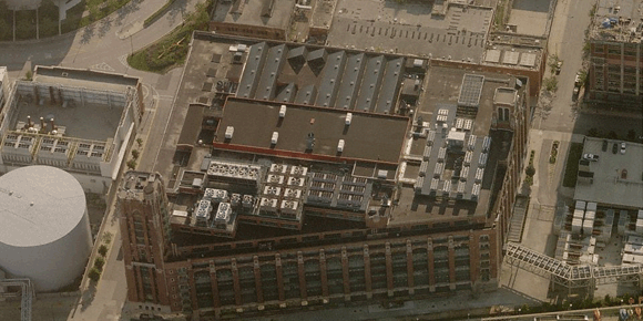
350 East Cermak Road, Chicago
The picture below shows one of Chicagos primary data centers, Digital Realty Trust’s facility at 350 East Cermak Road, which shows the large diversity in different types and sizes of cooling equipment at their roof.
Roof Capacity
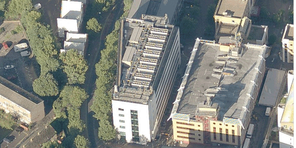
TeleCityGroup Sovereign House, London
Often large data centers within the city have very limited roof space available compared to the amount of equipment they house, forcing them to pack a lot of equipment very close together on the roof. Below is an aerial shot of one of TeleCityGroup’s primary facilities in London, Sovereign House in Docklands, showing how densely their roof is packed.
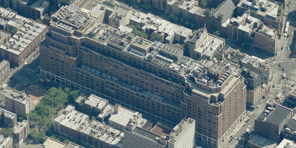
111 Eight Avenue, New York
The huge carrier hotel at 111 Eight Avenue in New York is another great example of a large inner-city facility with a lot of equipment on the roof, and in a much larger scale than Sovereign House above.
Birds-eye view via Microsoft Live Maps can be viewed directly on most of the data centers listed at Data Center Map, just go to a data center profile and click the “Map” tab.
Got any other examples of interesting data center views from the sky? Feel free to share.
Other interesting shots could for example include data centers with solar panels etc.